How to draw a sector graph
Full BASIC has no exclusive command which draws sectors.
To draw a sector, we approximate the sector with a polygon, assign all the coordinates of vertices to a two -dimensional array, and apply a MAT PLOT statement.
The following program draw a sector graph.
We use the fact that the coordinates of the point rotated clock-wise by θ from the top of the unit circle are (sinθ, cosθ).
A sector is approximated with a 1002-gon.(1001 points are used for an ark.)
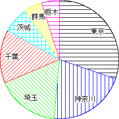
100 DATA "東京", 1257
110 DATA "神奈川",879
120 DATA "埼玉",705
130 DATA "千葉",605
140 DATA "茨城",297
150 DATA "群馬",202
160 DATA "栃木",201
170 DECLARE EXTERNAL PICTURE sector
180 SET WINDOW -1,1,-1,1
190 SET AREA STYLE "HATCH"
200 LET t=0
210 DO
220    READ IF MISSING THEN EXIT DO:s$,n
230    LET t=t+n
240 LOOP
250 RESTORE
260 LET a=0
270 LET i=0
280 DO
290    LET i=i+1
300    SET AREA COLOR i
310    SET AREA STYLE INDEX MOD(i-1,6)+1
320    READ IF MISSING THEN EXIT DO:s$,n
330    LET d=n/t*360
340    DRAW sector(a,d,s$)
350    LET a=a+d
360 LOOP
370 END
1000 EXTERNAL PICTURE sector(a,d,s$)
1010 OPTION ANGLE DEGREES
1020 DIM p(0 TO 1001, 2)
1030 FOR i=0 TO 1000
1040    LET t=a+d*i/1000
1050    LET p(i,1)=SIN(t)
1060    LET p(i,2)=COS(t)
1070 NEXT i
1080 LET p(1001,1)=0
1090 LET p(1001,2)=0
1100 MAT PLOT AREA:p
1110 SET TEXT JUSTIFY  "CENTER","HALF"
1120 SET TEXT BACKGROUND "OPAQUE"
1130 PLOT TEXT ,AT SIN(a+d/2)*0.8, COS(a+d/2)*0.8:s$
1140 END PICTURE
This is the composition rate of the population of 7 prefectures.
Total population of all prefectures is worked out in lines from 200 to 240.
Sectors that are in proportion to the population are drawn reading the population again in lines from 250 to 360. Numerical values are converted as to the total is 360.
The external picture sector(a,d,s$) draws a sector of angles from a° to (a+d)° in the clock-wise measure starting the top of the circle, and the label designated by s$.
Supplement Another example "sector.bas" lies in the "SAMPLE" folder.
Back